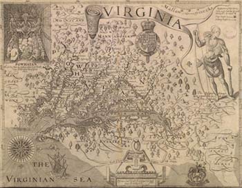
Map of the Chesapeake Bay by John Smith (ca. 1580-1631)
(from American Treasures of the Library of Congress)
1570
- The Spanish Jesuits establish the Ajacán mission on the Chesapeake Bay. The Spanish describe the bay as "the best and largest port in the world."
1607
- The London Company reaches the Chesapeake Bay in April and sails up a river they call the James in honor of King James. Sixteen members have died in transit and 50 more will die in the first year. Capt. Newport returns to London, leaving Capt. John Smith in charge.
1608
- Capt. John Smith surveys Chesapeake Bay and the Potomac River through much of the summer and says of the Potomac, "Neither better fish, more plenty, not more variety for small fish had any of us ever seen in a place."
- Capt. Newport arrives at Jamestown in September with a second supply ship. He finds that disease and malnutrition have reduced the original contingent to a group of 40. He departs in December with Smith's map of the Chesapeake Bay and its rivers
1632
- Maryland is chartered as the first of the English proprietary colonies in the New World. Land from the Potomac River north to the 40th parallel is granted by Charles I to Cecilius (Cecil) Calvert.